25 Forage Fish Index
Last updated July 23, 2026
Description: Aggregate forage fish biomass index from fish stomach contents
Contributor(s): Sarah Gaichas, James Gartland, Brian Smith, Anthony Wood, Elizabeth Ng, Michael Celestino, Katie Drew, Abigail Tyrell, and James Thorson
Affiliations: NEFSC
Indicator Family:
Indicator Category:
Synthesis Theme:
25.1 Introduction to Indicator
The amount of forage fish available in the ecosystem combined with the energy content of the forage species determines the amount of energy potentially available to predators in the ecosystem. Changes in the forage base could pose a risk to managed and protected species production. Spatially explicit indices of abundance for several forage species were estimated using spatio-temporal modeling (VAST, [12]; [13]). This spatially-explicit forage index estimated the combined biomass of 21 forage species using stomach contents information from 22 predatory fish species collected on bottom trawl surveys.
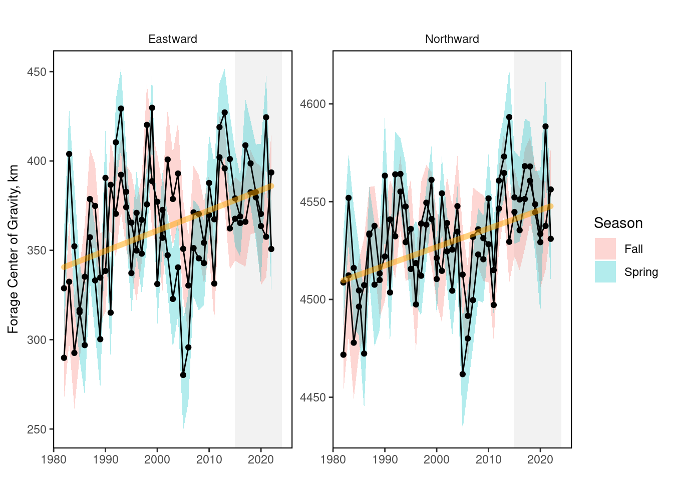
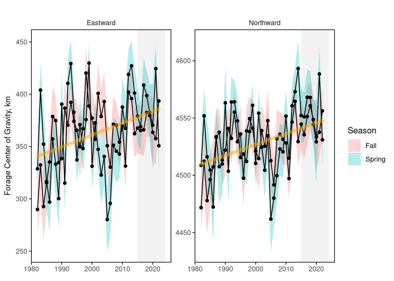
In addition to an index of forage abundance in each EPU, the coastwide center of gravity for the combined forage biomass was estimated. Consistent movement of the center of gravity towards the north or east indicates a distribution shift for combined forage fish.
25.2 Key Results and Visualizations
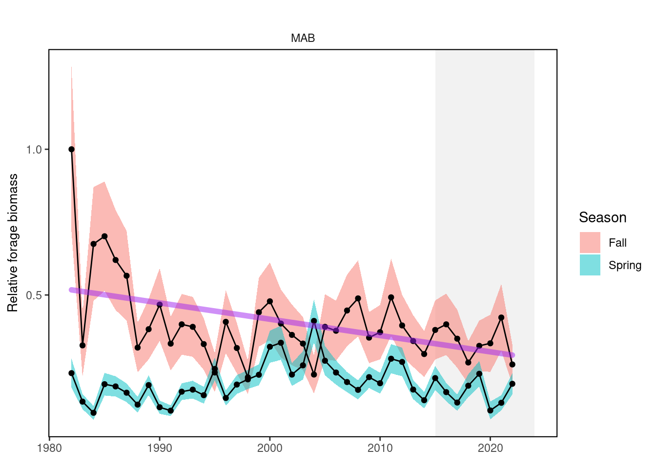
The plots below show spring and fall forage biomass, with standard errors. Long-term trends show that forage biomass is declining in the MAB in the fall and increasing in the GOM in the spring.
Mid-Atlantic, index
New England, index

Mid-Atlantic, cog
New England, cog
25.3 Implications
The resulting indices for the Mid-Atlantic show a long term decrease in fall and overall higher forage fish in fall relative to spring, with highest forage biomass during fall in the early-1980s.
In New England, the forage index shows an overall higher forage fish biomass in fall relative to spring. There is a long-term increasing trend in the spring in GOM.
Changes in the distribution of forage biomass also affects predator distribution. Since 1982, the fall center of gravity of forage fish has moved to the north and east. The spring forage center of gravity shows higher variability than fall, and a significant trend to the north.
25.4 Indicator statistics
Spatial scale: by EPU and full shelf
Temporal scale: Spring (January-June), Fall (July-December)
Variable definitions
25.5 Get the data
Point of contact: Abigail Tyrell (abigail.tyrell@noaa.gov)
ecodata dataset: ecodata::forage_index
Tech Doc link: https://noaa-edab.github.io/tech-doc/forage_index.html
25.5.1 Public Availability
Source data are publicly available. Initial model development (used in the SOE published in 2023-2025) is available at: https://github.com/NOAA-EDAB/forageindex Code for data updates (used in the SOE published in 2026-present) is available at: https://github.com/NEFSC/READ-EDAB-VAST_indices/tree/main/forage